|
|
|
Return To Gallery Menu
|
| |
|
Clermont County Farm Bureau
|

|
Picture posted to fb by Jeff Wood on August 26, 2021. Description from post.
Clermont County Farm Bureau Cooperative Association
Rusty Gribble, this one is for you.
Until very recently the only thing I knew of about the Clermont County Farm Bureau Cooperative Association was that it existed and where it existed at.
And the obscure layout of the tracks on the 1963 track chart that showed where it was at.
I had plenty of drawings of Batavia from the west end of Batavia siding all the way up Batavia hill and beyond.
The one thing I did not have was a drawing on that tiny little corner west of the Main street bridge over, well, Main street where Batavia station once stood.
I had heard people talk about it and even got to talk to a trainman who switched this area out.
That old saying, all things come to those who wait. Well sometimes, you have to go looking for and get that thing instead of waiting for it.
Thus I did. Back in May, I placed my 88th order for drawings from the NWHS archives. Five drawings, two of which were for the Clermont County Farm Bureau Cooperative Association. Thank you Rusty for asking.
Finally something solid to look at and study.
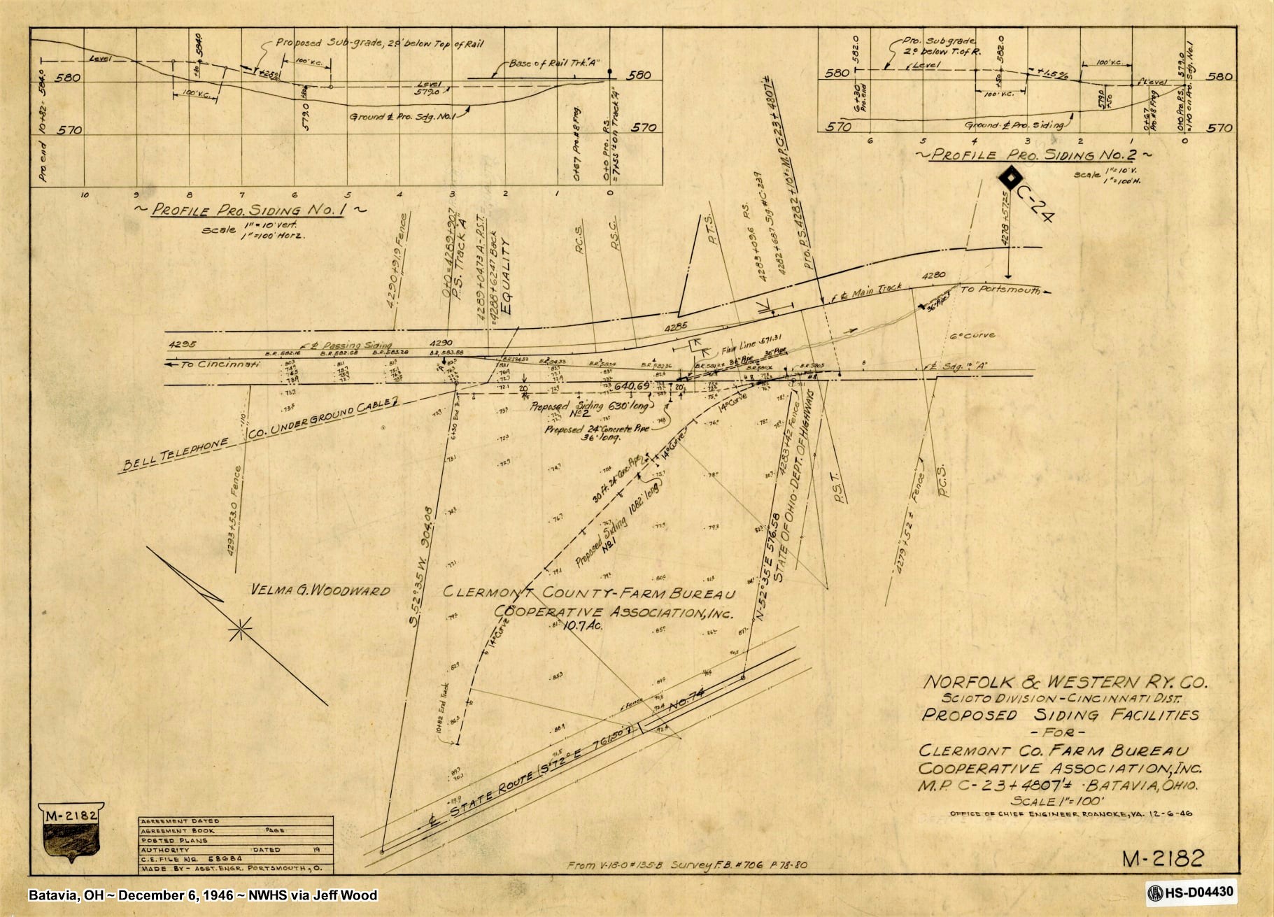
Drawing RR# M-2182 is dated 12-6-1946, for a proposed siding of 1082 feet long and another siding for 630 feet long.
These ran off the “A” siding that came of the main.
Drawing RR# M-2182-A is dated 3-31-1949, for a proposed siding of 800 feet long.
This area is just short of milepost C-24. Very short. MP C-24 is between the east end of Batavia siding and the Main street bridge.
As for why in 1946 there was a proposed siding of 1082 feet. Then three years later in the same spot there is one for 800 feet, I have now idea. Hey, don’t shoot me, I’m just the messenger.
When I toggle between both drawings, they line up danged near purfect.
The track layout on the 1963 track chart shows quite a jumble of trackage in this corner of Batavia. Obviously, there is more to learn of this area as the two drawings do not show as much trackage as the 1963 track chart.
Last year I did some exploring in this tiny little corner closer to the bridge looking for any signs of where the Cincinnati Georgetown & Portsmouth railroad crossed under the N&W in the curve just east of the east end of the siding.
No signs found I, but did get a piece of very dark ruff brick with a “P” embossed in it. I do not know if there are any remnants of the sidings for the Clermont County Farm Bureau Cooperative Association. I did find a foundation in this tiny little corner though. I also do not know if any of the building still standing were associated with the Clermont County Farm Bureau Cooperative Association.
I am so glad for copy and paste.
I have taken a screen shot with the phone to share with this story line to give an idea of where the Clermont County Farm Bureau Cooperative Association was located.
Any more info anyone can share about the, well you know, Rusty and I would much appreciate it.
One final note. as you know I have been cataloging all my archive drawings. I am up to White Oak east of Mt. Oreb now.
Rusty asking about the farm bureau gave me my first chance to look up a drawing from this new list. It was easy peasy.
|
| |
|
Location:
Batavia, OH
|
Date: 12/6/2046
|
|
Source:
Jeff Wood Personal Collection
|
|
Photo or Original Source Credit:
N&W Historical Society
| (http://www.nwhs.org/)
|
|
Photo ID: 2529
|
|
Photo Link:
Click Here To See Original
|
|
Categories:
Batavia Siding |
Peavine Documents |
|
|
|
|
|
|
|
