|
|||||||||||||||||||||||||||||||||||||||||||||||||||||||||||||||||||||||||||||||||||||||||||||||||||||||||||
| WO Story: About | Prototype Industries | 1987 Insection Trip | 1965 Time Table | Peavine Photo Gallery | Walk The Line | ||||||||||||||||||||||||||||||||||||||||||||||||||||||||||||||||||||||||||||||||||||||||||||||||||
| ABOUT THE REAL PEAVINE | ||||||||||||||||||||||||||||||||||||||||||||||||||||||||||||||||||||||||||||||||||||||||||||||||||
|
The Norfolk Southern Peavine between Cincinnati, OH and Portsmouth, OH is an ideal subject for modeling. The line has more than a hundreds years of history,
played host to famous named passenger trains, includes a lot of scenic diversity and a variety of industries for hours of interesting operation.
In recent years, the line has taken on the role of a short line. In the years since Conrail was divided between CSX and the Norfok Souther, the Peavine has gradually been downgraded. At the time of this writing, the line is currently closed between Rarden, OH and Portsmouth. The primary reason / excuse for this being the Scioto River bridge just west of Vera Junction north of Portsmouth. But the Peavine is alive. And possibly growing. Cincinnati East Terminal (CCET) is operating the line out of the old Clare Yard in Mariemont. The same Clare Yard depicted in this layout. CCET is owned by Frontier Rail. The primary industry for CCET is Huhtamaki, a consumer goods packaging company using the old Batavia Transmission plant in Afton, and Winchester Grain Elevator in Winchester, OH. Rumors on the internet indicate more opportunities may be in the works. This railfan has his fingers crossed in hope. *****
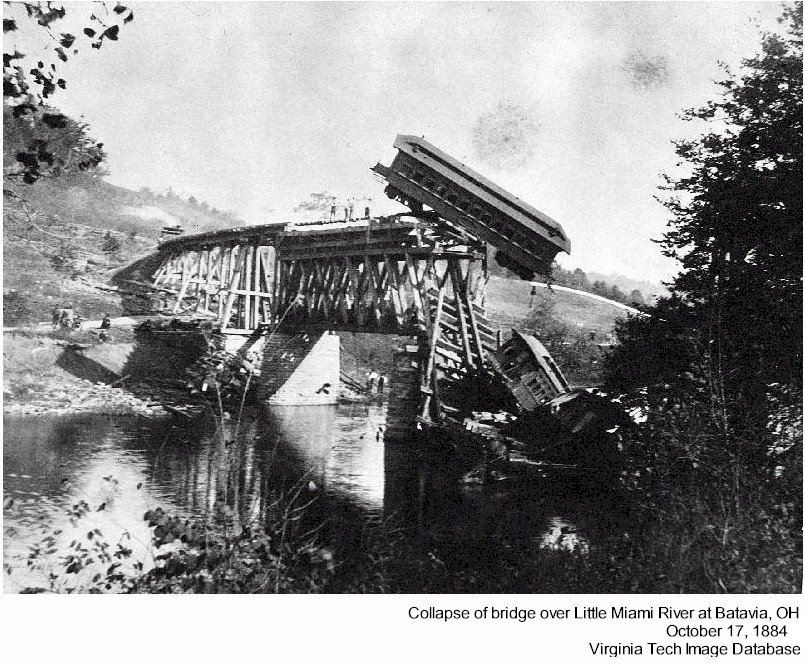
During the early years, the line was converted to standard gauge. This led to the most dramatic moment in the lines history. On October 17, 1884, a passenger train traveling east through Batavia, crossed the East Fork of the Little Miami River bridge just past the depot. Engineers did not account for the additional weight of the standard size cars. The bridge failed. Reports vary on injuries and deaths. I've linked a few sources below if you are interested in some of the details {2A, 2B, 3}. The line also experienced extensvie flooding in the years prior to the dams being build on the Ohio River. Clare Yard was submerged under water backing up the Little Miami River from the swollen Ohio River. In March 1933 the Scioto River bridge at Portsmouth was right at the water line, and the approaches may have been submerged (Click Here). If you are not familiar with the flood of 1933 or 1937 and are interested in history, google it. Through the first eight decades of the 1900s, the Peavine was a critical part of the Norfolk and Western system. Clare Yard was the western end of the railroad. From Clare the N&W interchanged with all the other class 1 railroads in Cincinnati. The Pennsylvania Railroad crossed the N&W at the east end of Clare, and the PRR's Undercliffe Yard was just a couple miles west. The N&W also interchanged with the PRR at Idlewild. And from Idlewild the line switched back to access the yards at Union Terminal. The N&W could also go north out of Clare, through Norwood and Sharonville where the could interchange with the New York Central. At one time, Cincinnati was home to the N&W, Pennsylvania, New York Central, Baltimore and Ohio, Chesapeake and Ohio, Louisville and Nashville and Southern. When Union Terminal was opened in 1933, passenger travel in and out of Cincinnati had an undisputed home. The N&W contribution to this was the Pocahontas and the Powhaten Arrow 1st class passenger trains. These trains were often pulled by streamline steam engines such as the J Class popularized by the restored 611. Passenger service continued into the 1960 before fading away on the Peavine. In recent years, the line has been rumored as a candidate for light rail service to downtown Cincinnati. The route of the Peavine is part of what make the line an interesting modeling subject. The Peavine runs between the numerous interchange posibilities in the west at Cincinnati to Portsmouth, OH. At Portsmouth, the Peavine merges with the Norfolk Southern's line to Columbus at Vera Junction. The line to Columbus is by far the busier of the two (even when the Peavine was at full song). Both ends of the Peavine are bookmarked by junctions followed immediately by a long river crossing over major Ohio River tributaries. Both terminal cities are rivertowns on the Ohio side of the Ohio River. But the line runs inland away from the Ohio River. The middle portion of the line is actually pretty flat and relatively straight. But it is also at a much higher elevation than the two ends. This means trains running either direction are faced with a long steep hill climb. Running west, the hill between Peebles and Lawshee was the challenge. Running east, the climb started at Batavia, OH and lasted 6.5 miles to Afton. The line was not busy enough, and the climbs not demanding enough to warrant helper service (at least that I know of). The N&W resorted to the less popular practice of doubling the hill. Long heavy trains would stop at the bottom of the hill, ideally leaving the back half of the train in or along a passing siding. The train would be cut at this point, with the conductor or brakeman riding the last car to signal the end of the train. The first half of the train would be taken to the top of the hill where it would be left on a passing siding. The engines would then run around the front of the train, run light down the hill to collect the back half. The train would be put back together to continue the trip. But you talk about operation interest... try blocking your single track main while a train doubles the hill. Along the 90 mile route between Cincinnati and Portsmouth, the tracks cross a number of bridges. This includes river crossings over the Little Miami River (at Clare), the East Fork of the Little Miami River, usually referred to as the East Fork River, (at Batavia and Williamsburg) and the Scioto River (at Portsmouth). Two steel tressels are highlights on the route. One is east of Winchester and the other west of Rarden. The line also cuts through several small towns. Going west to east, the Peavine goes through the towns and villages of Newtown, Batavia, Williamsburg, Mt. Oreb (spelled Mt. Orab everywhere but by the railroad), Sardinia, Winchester, Seaman, Peebles, Rarden and Otway. At each location, the railroad offers a dramatic break from the slow pace life of a small town. The Peavine was (and is in my altered history) home to a variety of industries. What I am aware of is from 1980 on, but I know there were more lineside industries in each town prior to that. What I am aware of includes grain elevators at Winchester and Sardinia, as well as grain elevators on the branch line (did I forget to mention the Peavine had a branch line!) at Mowrystown and Hillsboro. Trinity Corporation had a freight car building facility in Mt. Oreb where aluminum hoppers were built. For had a large transmission building plant in Afton. And a local steel fabricator in recent years has been making roller coaster sections. Now that makes for an interesting flat car load. I talk more about the industries of the Peavine on another page. Click Here for more information. ***** As far as activity on the Peavine, prior to the Conrail split, the line probably saw about eight to twelve trains a day. I don't have an actual count. Grain was a common source of traffic, headed from the midwest to the east coast. But what killed the line was when the NS got the Conrail line between Columbus and Cincinnati. So some amount of traffic moved between those to towns along the Peavine. The other two factors in the demise of the Peavine are the fact that the Peavine has a couple of locations that cannot clear doublestack cars, and the Scioto River brids needs (or supposedly needs) significant maintenance. Regardless, the Peavine is an ideal model subject. It existed for years as a class 1 mainline. It survives today as a shortline. You can reinvent the Peavine in many ways to make it a viable modeling subject. And on this web site, you'll see how I envision it as part of the regional Western Ohio Railway. |
||||||||||||||||||||||||||||||||||||||||||||||||||||||||||||||||||||||||||||||||||||||||||||||||||
|
Sources 1 - Wikipedia (https://en.wikipedia.org/wiki/Cincinnati_and_Eastern_Railway) 2A - GenDisasters.com (http://www.gendisasters.com/ohio/19960/batavia-oh-train-goes-through-trestle-july-1889) 2B - GenDisasters.com (http://www.gendisasters.com/ohio/22466/batavia-oh-train-wreck-oct-1884) 3 - Virginia Tech Image Database (https://imagebase.lib.vt.edu/view_record.php?URN=ns3739&mode=popup) |
||||||||||||||||||||||||||||||||||||||||||||||||||||||||||||||||||||||||||||||||||||||||||||||||||
|
|
||||||||||||||||||||||||||||||||||||||||||||||||||||||||||||||||||||||||||||||||||||||||||||||||||
|
Quick Link Menu | Home
|
||||||||||||||||||||||||||||||||||||||||||||||||||||||||||||||||||||||||||||||||||||||||||||||||||
|
Western Ohio Story Concept History System Map Peavine Division Layout About the Peavine Layout Track Plan Guiding Principles Engine Roster Industries |
Other Layouts Marien Switching District Offal, IN Branch Influences and Inspirations Favorite Layouts How Do Paperwork |
The Real Peavine About the Peavine Prototype Industries 1987 Inspection Trip 1965 Timetable Photo and Video Galleries Prototype Gallery Peavine Gallery Walk The Line Model Gallery |
About Owner: David Lamb Contact the WO About The Site About The Home Page Favorite Resources FB-Cincinnati Eastern Railroad FB-History of the Peavine RR Cincinnati Traction History YouTube - Jaw Tooth Channel |
|||||||||||||||||||||||||||||||||||||||||||||||||||||||||||||||||||||||||||||||||||||||||||||||
| Copyright 2013 - 2025 | ||||||||||||||||||||||||||||||||||||||||||||||||||||||||||||||||||||||||||||||||||||||||||||||||||